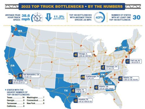
Top 100 Truck Bottlenecks – 2022

2022 ATRI Bottleneck Map

Since 2002, the American Transportation Research Institute (ATRI) has collected and processed truck GPS data in support of numerous U.S. DOT freight mobility initiatives. Using truck GPS data from over 1 million freight trucks, ATRI develops and monitors a series of key performance measures on the nation’s freight transportation system. Among its many GPS analyses, ATRI converts its truck GPS dataset into an ongoing truck bottleneck analysis that is used to quantify the impact of traffic congestion on truck-borne freight at over 300 specific locations. While other outside analyses may identify congested corridors, no dataset available today specifically identifies granular chokepoints in the nation’s truck freight transportation system.

Measuring the performance of freight movement across our nation’s highways is critical to understanding where and at what level investment should be made. The information provided through this effort empowers decision-making in both the private and public sectors by helping stakeholders better understand the severity of congestion and mobility constraints on the U.S. highway transportation system. With the November 2021 enactment of the Infrastructure Investment and Jobs Act, ATRI’s top truck bottleneck list is poised to guide investment decisions to address the nation’s supply chain challenges.

ATRI’s bottleneck analysis incorporates and synthesizes several unique components, including a massive database of truck GPS data at freight-significant locations throughout the U.S. and an algorithm that quantifies the impact of congestion on truck-based freight. In addition, the annual reports provide a chronological repository of mobility profiles, allowing congestion changes to be assessed over time. This allows transportation analysts and planners to conduct performance benchmarking, identify influential factors contributing to congestion, and understand the resulting consequences for freight mobility. Given the impacts on traffic congestion during the pandemic, this year’s list includes year-over-year average speed changes as well as a comparison of 2021 to 2019, which provides a pre-pandemic congestion benchmark.

States with a Top 100 Truck Bottleneck

States Not in Top 100

Congestion
Ranking
Congestion DescriptionStateAverage
Speed
Peak
Average
Speed
Non-Peak
Average
Speed
Peak Average
Speed Percent
Change
2020-2021
Peak Average
Speed Percent
Change
2019-2021
1Fort Lee, NJ: I-95 at SR 4NJ30.122.433.4-28.2%0.1%
2Cincinnati, OH: I-71 at I-75OH38.633.640.6-16.3%-6.7%
3Houston, TX: I-45 at I-69/US 59 TX33.224.437.2-22.4%19.3%
4Atlanta, GA: I-285 at I-85 (North)GA38.930.442.7-11.7%35.5%
5Atlanta, GA: I-20 at I-285 (West)GA41.937.243.9-9%2.4%
6Chicago, IL: I-290 at I-90/I-94IL24.420.325.8-20%26.1%
7Los Angeles, CA: SR 60 at SR 57 CA43.336.946.0-12.1%11.5%
8Dallas, TX: I-45 at I-30TX37.227.341.6-18.6%-1.7%
9San Bernardino, CA: I-10 at I-15CA42.235.744.8-12.1%9.9%
10Chattanooga, TN: I-75 at I-24TN47.945.848.7-2.3%-4%
11Nashville, TN: I-24/I-40 at I-440 (East)TN44.035.047.9-12.4%45.4%
12McDonough, GA: I-75GA48.044.049.5-10.9%-10.8%
13Houston, TX: I-10 at I-45TX41.230.546.5-23.2%22.6%
14Atlanta, GA: I-75 at I-285 (North)GA46.342.148.0-7.7%44.5%
15Houston, TX: I-45 at I-610 (North)TX41.031.046.0-19.7%18.7%
16Baton Rouge, LA: I-10 at I-110LA37.430.640.8-18.8%3.9%
17Rye, NY: I-95 at I-287NY46.644.547.2-2.6%9%
18Atlanta, GA: I-285 at SR 400GA44.537.047.8-25.9%19%
19Chicago, IL: I-80 at I-94IL49.447.150.3-8.2%-0.2%
20Brooklyn, NY: I-278 at Belt ParkwayNY34.929.537.3-12.6%16.1%
21Atlanta, GA: I-20 at I-285 (East)GA46.641.448.8-10.6%8%
22Denver, CO: I-70 at I-25CO39.931.744.1-18.3%6.9%
23Chicago, IL: I-90 at I-94 (South)IL43.336.945.6-10.7%16.1%
24Hartford, CT: I-84 at I-91CT49.044.850.4-5%36.7%
25St. Louis, MO: I-64/I-55 at I-44MO46.445.446.8-1.6%8.4%
26Philadelphia, PA: I-76 at I-676PA30.326.131.8-15.2%11.6%
27Austin, TX: I-35TX36.227.439.3-8.5%74.7%
28Portland, OR: I-5 at I-84OR37.332.339.5-13.7%40.6%
29Chattanooga, TN: I-24 at US 27TN47.240.350.4-15.4%6%
30Houston, TX: I-10 at I-610 (West)TX47.538.551.6-14.3%23.1%
31Queens, NY: I-495NY24.917.229.1-16.8%14.4%
32Providence, RI: I-95 at I-195RI41.336.243.6-13.2%14.3%
33Vancouver, WA: I-5 at Columbia RiverWA45.443.246.2-1.8%22%
34Houston, TX: I-610 at US 290TX44.334.649.5-18%12.8%
35Corona, CA: I-15 at SR 91CA45.040.046.8-8.7%18.4%
36Tacoma, WA: I-5 at I-705/SR 16WA43.737.746.5-12.1%18.8%
37Stamford, CT: I-95CT43.934.547.1-15.6%9.9%
38Chicago, IL: I-90 at I-94 (North)IL38.626.443.9-27.1%59%
39Bronx, NY: I-678NY32.228.134.1-23.4%8.7%
40Denver, CO: I-70 at I-270CO44.037.247.4-7.5%31.4%
41Houston, TX: I-10 at I-610 (East )TX50.144.552.6-9.5%5.9%
42Memphis, TN: I-55 at I-40TN49.848.650.2-11.7%-11.7%
43Philadelphia, PA: I-476 at I-95PA44.141.845.0-11.0%26.3%
44Seattle, WA: I-5 at I-90WA36.027.640.2-14.8%7.8%
45Atlanta, GA: I-20 at I-75/I-85GA41.835.144.2-15.6%30.4%
46Philadelphia, PA: I-76 at US 1PA35.929.138.9-20.8%32.7%
47Oakland, CA: I-880 at I-238CA43.938.146.9-13.1%18.5%
48Federal Way, WA: SR 18 at I-5WA45.538.648.8-14.3%17.2%
49Nashville, TN: I-40 at I-65 (East)TN45.238.747.9-6.5%46.6%
50Detroit, MI: I-94 at I-75MI47.244.248.6-6.5%15.7%
51Waterbury, CT: I-84 at SR 8CT46.343.547.3-6.2%-8.1%
52Atlanta, GA: I-75 at I-675GA49.452.048.6-3.6%-4.9%
53Indianapolis, IN: I-65 at I-70 (North)IN47.040.949.9-13%18.5%
54Dallas, TX: US 75 at I-635TX47.239.850.2-6.7%21.9%
55Gary, IN: I-65 at I-80IN52.050.552.6-3.5%3.8%
56Norwalk, CT: I-95CT46.638.349.4-17.5%25.7%
57Nashville, TN: I-65 at I-24TN49.444.151.5-7.9%19.8%
58Denver, CO: I-25 at I-76CO48.640.352.2-12.1%7.9%
59Los Angeles, CA: I-110 at I-105 CA41.734.544.8-13.1%21.3%
60Ft. Worth, TX: I-35W at I-30TX46.437.950.0-13%4.2%
61Charleston, SC: I-26 at I-526SC44.735.749.4-13.4%5.2%
62Atlanta, GA: I-75 at I-85GA40.733.143.5-15.0%41.1%
63Oakland, CA: I-80 at I-580/I-880CA34.829.737.0-16.1%25.2%
64Knoxville, TN: I-40/I-75 at I-140TN50.342.454.6-18.4%-3.7%
65Houston, TX: I-610 at I-69/US 59 (West)TX42.035.045.0-11.7%22.4%
66Philadelphia, PA: I-76 at I-476PA47.444.248.8-8.7%24.7%
67Auburn, WA: SR 18 at SR 167WA47.442.649.6-6.9%19.2%
68Houston, TX: I-45 at Sam Houston Tollway (North)TX49.242.252.2-14.8%3.5%
69Tampa, FL: I-4 at I-275FL41.633.945.2-11.8%21.1%
70Stafford, VA: I-95VA48.144.049.7-10.4%14.7%
71Cincinnati, OH: I-75/I-71 at I-275OH51.448.052.86%11.5%
72Minneapolis – St. Paul, MN: I-35E at I-94MN46.542.948.2-7.2%29%
73Manhasset, NY: I-495 at Shelter Rock RoadNY44.236.347.7-12.2%12.2%
74Nyack, NY: I-287NY48.741.851.5-16.4%17.4%
75Kansas City, MO: I-70 at I-670 at US 71MO48.844.150.7-7.4%14.8%
76Seattle, WA: I-90 at I-405WA41.033.944.4-15.6%18.6%
77Richland, MS: US 49MS37.635.838.3-7.9%-8.3%
78Phoenix, AZ: I-17 at I-10AZ49.442.652.3-7.0%43.9%
79Bridgeport, CT: I-95 at SR 8/SR 25 CT50.241.153.3-18.8%1.5%
80Charlotte, NC: I-85 at I-485 (West)NC52.047.254.2-6%16.6%
81Las Vegas, NV: I-15 at I-515NV49.243.851.9-10.5%5.2%
82New Haven, CT: I-95 at I-91CT52.548.153.80%22.2%
83Portland, OR: I-5 at I-205 (South)OR47.941.651.1-11.8%15.6%
84Minneapolis – St. Paul, MN: I-35W at I-494MN49.746.051.3-5.9%36.6%
85Indianapolis, IN: I-465 at I-69IN51.346.553.4-7.5%11.4%
86Camden, NJ: I-76 at I-676NJ45.543.046.5-7.5%6.6%
87Greenville, SC: I-85 at I-385SC52.346.355.0-12.4%22%
88Knoxville, TN: I-40 at I-275TN51.346.153.7-11.4%5.6%
89Milwaukee, WI: I-94/I-794 at I-43WI47.742.550.3-11.1%31%
90Los Angeles, CA: SR 91 at SR 55CA48.442.750.3-8.3%6.6%
91Los Angeles, CA: I-710 at I-105CA49.342.352.48.1%67.8%
92Washington, DC: I-95 at I-495 (North)DC49.342.352.4-12.6%28.1%
93Houston, TX: I-10 at I-69/US 59TX48.138.553.2-20.2%14.4%
94Tacoma, WA: I-5 at SR 512WA49.646.151.0-4.3%5.7%
95Nashville, TN: I-65 at SR 386TN50.844.053.9-9.4%0.5%
96Cincinnati, OH: I-75 at I-74OH50.746.452.4-4.6%21.9%
97Charlotte, NC: I-77 near Lake NormanNC48.440.752.9-15.9%20.5%
98Houston, TX: I-45 at I-610 (South)TX46.839.650.6-10%15.2%
99Boston, MA: I-93 at SR 3MA42.635.446.5-16.7%44.6%
100Baltimore, MD: I-695 at I-70MD50.946.252.8-5.8%35.1%